

Paving Paradise
Critics fear a highway bypass could trigger development in Heber Valley's open spaces and threaten a critical water source.
By Eric S. Peterson @ericspeterson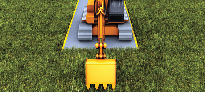
The following story was reported by The Utah Investigative Journalism Project in partnership with Salt Lake City Weekly, Daily Herald, The Park Record, and KPCW.
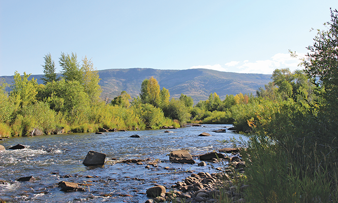
Brian Wimmer, president of the Trout Unlimited chapter of Utah County, has been casting his flies into the Middle Provo River for years. He's learned that it doesn't matter how long you've been tying and casting flies, you can't control the river or when and where fish will bite—and that really is the whole point.
"When you give yourself up to the possibility that you're not going to be able to control it, then it's about letting go and letting it happen," Wimmer said. At this level of enlightenment, you can bask in the serenity of standing still in a ceaseless and wild river. Maybe hooking dinner, maybe not.
Understanding that the river is bigger than you is the ultimate reward. And it's a lesson Wimmer wishes the Utah Department of Transportation (UDOT) would heed.
For the past two years, UDOT officials have been planning a highway bypass to relieve traffic congestion through Heber City. The agency has already conducted lengthy studies and narrowed down a list of five possible routes through the Heber Valley.
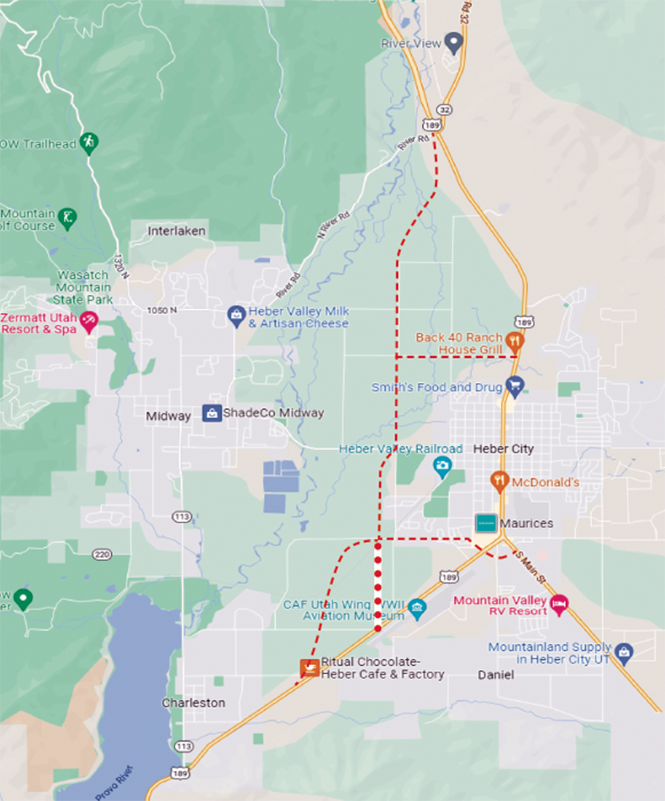
On paper, two of these routes appear as innocuous, straight, black lines connecting U.S. 40 at the northern entrance to the valley around Heber City to State Route 32 to the south. But for critics, these straightforward road lines—if built—would cut in half the valley's iconic north fields, threaten the health of the pristine Provo River and possibly trigger the kind of development across the valley floor that would make the postcard-like vistas resemble any other paved-over suburban community in Utah that decided to trade its pastures and streams for Walmarts and condos.
Wimmer doesn't doubt that UDOT has good intentions. But he says he has witnessed too many instances over the years when construction crews took shortcuts that meant harmful pollution to the river.
"It's too easy to mess up, because we just do not play God very well," Wimmer said.
Wimmer insists he's not just an ornery angler, noting the water isn't just for the trout but also serves the culinary needs of most of Utah County and parts of Salt Lake County—with the Provo River watershed serving as source water for 65% of the state's population.
Currently, UDOT is working on the first draft of its Environmental Impact Statement. The EIS is the official report on how these different highway route options could impact the local environment. Not only does it help guide local leaders, it's also required by federal law.
UDOT officials have already taken early public comment and used the feedback to promise to address issues of major concern. But one acute anxiety for residents is the possible pollution and broader impacts that result from further development that might—and likely would—blossom along the new bypass.
In its formal response, UDOT committed to studying the "foreseeable" impacts of development. But in an interview, Heber Valley Bypass project manager Craig Hancock acknowledged that "foreseeable" only means looking at what the current zoning allows for, and that UDOT has not closely examined plans of property owners in the valley.
"We refer back to the cities and their zoning laws," Hancock said.
In reviewing county land records since 2020, however, The Utah Investigative Journalism Project has identified more than 100 acres of parcels bought by a handful of developers across the valley that could turn a profit with help from the bypass—and potentially impact the river at the same time.
Twists and Turns
How is it that apartments and parking lots can blossom and flourish along the edges of a highway like reeds on a riverbank?
For Michael Mills, the building of a road often gives cities the opportunity to also install utility and sewer lines at a fraction of the cost, since another agency like UDOT would be footing the excavation bill.
"That kind of infrastructure supports more development," said Mills, deputy executive director of the Utah Reclamation Mitigation and Conservation Commission.
Wendy Fisher is executive director of Utah Open Lands, an organization that works to preserve open space through conservation easements that pay landowners to voluntarily protect their lands from future development. She, too, warns that a highway can easily strangle open-space preservation.
"How many farm owners want to have their farms split in half by a fairly significant road, and then want to conserve it?" Fisher asked. She said having that land dissected by a highway might convince the landowner that it's not worth preserving anymore and might as well be sold and developed in the future.
For Mills, the idea of a road jeopardizing the river is especially troubling given the twists and turns in the history of the river itself.
In the 1950s and 1960s, the Central Utah Project brought water from the Colorado River into the heart of Utah. Dams and dikes were placed on the Provo River as part of that project. A feat like only Paul Bunyan could have accomplished, they tamed the wild river, straightening it to force a faster and more direct flow to the state's population centers.
Unfortunately, it wasn't well understood at the time how much life flourished in the river bends, so the fish died, and the animals that fed on them left. Wetlands were destroyed, and forest habitat was lost.
Mills was part of the Provo River Restoration Project, aimed at undoing this folly. Between 1999 and 2008, the $45 million project recreated the bends of the river and rebuilt the habitat through painstaking effort. After healthy vegetation was planted, the ecosystem required constant monitoring. In addition, the commission needed to acquire land for an 800- to 2,200-foot-wide corridor the length of the river between Jordanelle Dam and Deer Creek Reservoir.
Today, the river is once again flush with trout and anglers, and the banks teem with birds and birdwatchers.
"I'm obviously biased, but it feels like a jewel for the Heber Valley," Mills said. He's frankly worried that, after such a victory, the state would now plan a highway to run parallel to the river.
"It's like somebody gets cut, the doctor stitches them up, and then someone else comes along and just cuts the stitches," Mills said.
'Boots on the Water'
While UDOT has been meeting with stakeholder groups for the past few years, those discussions have primarily included interested parties in the Heber Valley. End users, especially those downstream in Utah County, said they had not been involved in these early discussions.
Representatives of public works departments for both Provo and Orem also said they had not been included.
Keith Denos, general manager of the Utah County-based Provo River Water Users Association, was only made aware of the project when asked by a reporter. He said he needed to study it and couldn't comment for his organization, but personally understood the challenge UDOT was undertaking on behalf of Heber City.
"I remember 20 years ago, Heber was a sleepy little town," Denos said, but now it feels like "a massive traffic jam" every time he's there. He adds, though, that the river and the north fields are irreplaceable. "That's a place every valley wishes they could preserve."
But how long these wide open spaces can withstand the push of development is a big question. A 2017 report from the Kem C. Gardner Policy Institute at the University of Utah projected that Wasatch County would be the second-fastest-growing county in the state, seeing a population increase of 187% between 2015 and 2045.
The Heber Valley Bypass process kicked off in 2020, with UDOT looking to help drivers better move across the valley and to support the city's plan for revitalizing its historic town center.
Hancock, the project manager, says UDOT started with 23 alternative routes and recently narrowed the list down to five. Three of the routes avoid cutting through the largest swathes of the scenic north fields by veering off Highway 40 near the entrance of town.
Each of these road alternatives are measured not only against the need and purpose—easing vehicle congestion and supporting Heber's downtown—but also against potential negative impacts to the local environment.
Hancock noted that no plans would directly impact the river.
"What we're not doing is creating a dam with the road—there's not something planned that's going to block any of the water," Hancock said.
Instead, UDOT will focus its attention on Provo River feeder streams and creeks that will be affected. He says UDOT is planning on retention ponds and other filtration systems to protect the river as well as surrounding groundwater and wetlands.
Even with such well-thought-out plans, Wimmer, of the Provo Trout Unlimited chapter, is concerned about careless construction crews. He points to a dam rehabilitation in 2016 that released black sludge down American Fork River, killing thousands of fish. Or, more recently, the concrete slurry that washed through Mill Creek in 2021 from an Interstate 215 construction project overseen by UDOT.
Wimmer said it's often anglers, as the "boots on the water," who ultimately spot these kinds of spills that might otherwise go undetected.
"This is the mentality of the construction world," Wimmer said. "They are always going to come in over budget so they start cutting corners. Next thing you know, they start flushing stuff down the river, and if no one sees it, 'no harm, no foul.'"
For Zach Frankel of the Utah Rivers Council, the place where the rubber hits the road for polluters is literally the rubber hitting the road. A major concern is tire debris that collects on roadways and gets washed off during storms into surrounding areas.
There's so much at risk, it makes him question what's to be gained with the proposed bypass construction.
"At some point, we need to ask ourselves why we live here," Frankel said. "I would argue it's not because we might be able to make a trip three minutes shorter. It's because of the landscape, it's because of the quality of life."
Pure Speculation
While UDOT has planned to estimate the impacts of development from the road, they have limited that only to current zoning and plans.
Naomi Kisen, UDOT's environmental program manager, said that means consulting with local planning authorities.
"If [developers] submitted plans to the local government authority that approves those plans, then we take that into consideration," Kisen said.
This, however, doesn't account for purchases made by shrewd land speculators, especially those who have already bought land but won't seek new zoning or permitting until the conditions are right—like if their property is accessible via a new highway, for example.
In a search of county records, The Utah Investigative Journalism Project identified more than 148 acres of land purchased across the north fields area since 2020, when the UDOT process officially began. All of these parcels would be in close proximity to the north field routes and many would be adjacent to the Provo River.
Take, for example, 10 acres purchased near the Provo River and along 2400 North, where one of the UDOT routes would intersect. The parcel was acquired by a company called Big Water Ranch LLC. The owners of that company—Jeff Danley and Jason Danley—aren't cowhands but executives at Peak Capital Partners, a Provo-based company that develops apartments and multifamily properties.
Peak Capital's website shows a portfolio of units across 25 states, noting its properties represent "strong long-term growth opportunities," cultivated through "relentless due diligence."
"We maintain a broad sourcing network and productive relationships with brokers, property owners, developers and municipal leaders in each target market," the Peak Capital website states.

Another company, Timpview Investment Holdings, has acquired more than 50 acres near the proposed UDOT routes since 2019, when the bypass was only informally discussed. That company has already proposed that Heber City annex its land just north of Wasatch County Park for a future development that would include open spaces as well as multi-family affordable residential developments. The proposed developments would run close to Spring Creek, which feeds into the Provo River.
Another 16 acres was scooped up in February—at the spot where the new north field routes would turn off from U.S. 40—by an entity called KLJB LLC, the members of which are firm principals in a company called Mountain States Property Management, a real-estate development company out of Logan.
All such acquisitions are perfectly legal and may be quite strategically located if the routes are approved and local government in the future warms to the idea of development around the bypass.
For UDOT, however, they won't factor into the environmental or other development impact studies until plans are filed.
"The bypass road doesn't change the zoning in the valley," Kisen said.
Forever Deeds
Or does it?
That's the question on the minds of open-space advocates. Which comes first, they ask: the road or the development? If a road is built that cuts across open space, does it incentivize a move toward developing around the road?
Michael Henke, planning director for Midway City, worries that's exactly what will happen.
"The road could make it easier to develop those areas," he said.
Midway actually bonded $5 million to help fund conservation easements, including for north field areas, in 2018. That same year, Wasatch County also approved a $10 million bond. Now, open-space advocates have to wait to see if those plans could be thwarted by a UDOT condemnation.
The bonds give landowners a chance to keep generational farms intact or to have them converted into public trails or open spaces. Sometimes, it just means a promise to leave it green, even if there isn't public access.
"There's a lot of value even in just seeing the land open," Henke said.
For Fisher, with Utah Open Lands, conservation easements are valuable tools to create "forever deeds." But those opportunities to preserve could also be thwarted forever by projects like the bypass.
"Once there's a road, once you've destroyed that idyllic setting, you can't get it back," she said.
The Heber Valley Corridor draft EIS is set to be released this winter or in spring 2023, and the public will have an opportunity to provide comments. Learn more about the proposed routes by visiting hebervalleyeis.udot.utah.gov

More by Eric S. Peterson
-
The Secret Sauce
How Utah lawmakers disclose—or don't disclose—conflicts of interest.
- Feb 14, 2024
-
Police departments in Salt Lake County spent almost $20 million on civil rights complaints in the past decade
The Co$t of Mi$conduct
- Oct 18, 2023
-
Women decry harassment and toxic culture at St. George auto dealership
Men at Work
- Oct 11, 2023
- More »
Latest in Cover Story
Readers also liked…
-
Forget the family pedigree—Robert F. Kennedy Jr should not be the next president of the United States
Trojan Horse
- Jun 21, 2023
-
Women decry harassment and toxic culture at St. George auto dealership
Men at Work
- Oct 11, 2023

