

LDS Church & SLC Development
This Is the Place: The LDS Church eyes barren wetlands as a future city within Salt Lake City.
By Katharine Biele @kathybiele
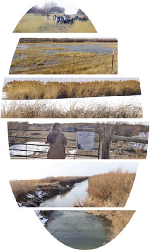
Here, eight miles from the urban capital, lie 19,000 acres of brush, streams and nearly forgotten landfills.
“Nearly” is the operative word. Plans are afoot to get a long-awaited master plan in gear for a proposed settlement that would permanently change the face of this urban capital.
Most assuredly, it would change the politics, too.
What is now home mostly to birds, mosquitoes and deer flies would eventually house up to 70,000 people in “a variety of neighborhoods with a range of housing types for a diverse population … minutes from downtown and the airport,” according to a recent update of the 2009 draft of the Northwest Quadrant Master Plan.
Located between Bangerter Highway and 8800 West, from 2100 South to 3700 North, the quadrant is the last major expanse of undeveloped land in the city. What is envisioned is nothing less than another city appended to the core. With 70,000 potential residents (the city’s principal planner, Everett Joyce, sees upwards of 300,000 in the future), the development would rival many cities in Utah.
This is Salt Lake City’s answer to Daybreak, the South Jordan megaburb that Kennecott Land Company built on recovered mining property, except the Northwest Quadrant sits on a floodplain dotted by aging landfills susceptible to earthquake liquefaction.
“I like to think it’s better than Daybreak,” says Salt Lake City Councilman Carlton Christensen. “This is an opportunity to develop a community that really espouses some of the core values we espouse in this city, and if it can’t, shame on us.”
The values Christensen talks about are things like sustainability, air quality and walkability. There are also values—albeit unspoken—of Utah’s conservative LDS majority that come into play.
Political Hay
“People
don’t like to talk about it much,” says former Salt Lake City Mayor
Rocky Anderson, never one to shy away from controversy. “This could
alter the political makeup of this community, and we could end up being
another Sandy.”
The master plan doesn’t exactly mention social engineering as a goal, and the area’s largest landowner—The Church of Jesus Christ of Latter-day Saints—is deferring to the city as to what those goals are. Questions about liquor licensing, free-speech areas and even dog ownership were answered simply: “We are a longtime property owner in the area—our ownership originally goes back years as a welfare farm. However, what our role in any possible development in the area might be is undetermined until Salt Lake City has determined its master plan for the area.”
As the LDS Church is the largest landowner, it seems only natural to inquire about the development through its property arms—Suburban Land Reserve and Property Reserve Inc. But questions sent to Carl Duke, property manager for SLR, were eventually fielded by the LDS Church’s communications department.
Stephen Goldsmith, former planning director for the city, was surprised at the easy interface between the entities. “I’m looking at the ethical construct of this,” he puzzles. “As the church began to reorganize their for-profit side, they moved [real-estate development] into different hands, and they have worked very hard to differentiate their ecclesiastical side from their commercial side.”
But the Northwest Quadrant holds such huge implications for both the city and the church that the church can’t simply pass it off as a garden-variety development project.
The church has often mentioned its history of stimulus aid amid poor economic times. According to a history by Garth Magnum, in the Depression ’30s, the LDS Church began its welfare system by placing unemployed urban Mormons with self-sufficient farmers. Perhaps there’s some irony in the fact that the church’s welfare goal for the Northwest Quadrant leaves farms behind in favor of an urban village.
The Green Edge
Whether
this plan stimulates positively or negatively is a question that
planners have yet to fully evaluate. Promises of bright development and
exciting opportunities are often just that. The Gateway was slated to
complement downtown Salt Lake City instead of draining the core of its
retail and business tenants.
The LDS Church, of course, has since stepped in to fill what The Gateway sucked away. It’s developing the massive City Creek Center where two downtown malls once thrived.
Salt Lake City Councilman S%uFFFDren Simonsen is concerned that the Northwest Quadrant development will suck even more from the city and its environs and could well sidetrack the already stalled plans to develop around transit stops. He’s been talking about the master plan for the past four years, but his strident advocacy of planning and sustainability haven’t earned him a lot of brownie points from his colleagues.
“I’m a bit dismayed with the process because I don’t think we’ve gone through an analysis of not building,” he says. “When you start with the assumption that you do only one thing—to develop it—then everything you put together in your toolbox supports your assumption.”
Manure in the Mix
Indeed, the plan is all about development. It “represents an important milestone in the continuing development of Salt Lake City,” the plan says.
“The purpose of this plan is to apply the community’s shared values and goals to the establishment of a basis for rational decision-making and planning-policy formulation by Salt Lake City’s decisionmakers regarding future development of the Northwest Quadrant area.”
“This is not just a plan for a subdivision; it’s a plan for a whole new town,” says Jennifer Gillmor Larson, whose family has ranched the area for 100 years. A 2007 visioning workshop came up with an, ahem, “sustainable” scenario to “balance and integrate the environmental, social and economic components of the community; meet the needs of existing and future generations; respect the needs of other communities in the region and globally; and preserve and enhance natural ecological functions.”
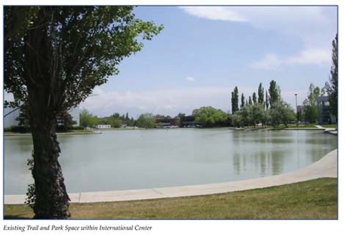
Contrast that picture-perfect vision with what’s actually there today: a winding dirt road from the airport’s International Center (left) dotted with warning signs against stopping, likely a safety precaution for the airport to keep terrorists or kids playing with laser beams at bay.
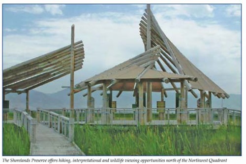
This will be a self-contained, idyllic village where residents could walk to a farmers market. Buildings will be “green,” constructed for the best possible energy use, and bridges and underpasses will cross natural habitat areas to “ensure continuous greenway connections.” Besides a town center, there will be a village center and neighborhood centers—all mixed-use gathering places for the diverse, eco-friendly population.
“A significant portion of the Northwest Quadrant will form a hierarchy of natural systems; create a green edge to Salt Lake City; buffer the Great Salt Lake and Bailey’s Lake; and create an internal greenway system within the developed portion of the Northwest Quadrant,” the plan says.
The emphasis on green is somewhat ironic given the lack of it in this area.
“There’s a good reason that we, the duck clubs and the Audubon are the only ones out there,” says Larson. “It already stinks to high heaven out there. The alkaline mud stinks and the mosquitoes and deer flies will eat you alive if you give them a chance.”
The Gillmors, whose properties intersperse the area, were recognized in 1996 by then-Gov. Mike Leavitt’s Century Farm and Ranch Program. The program has been more of a memo than an award. It highlights “farm families and provides a message to the broader public of the importance of sustaining the agriculture industry in the state,” said Bob Gilliland, director of Utah State University’s Cooperative Extension Service.
“This generation is still deeply committed to continue that family tradition. It’s not just a job; it’s a way of life,” Larson says. The Century Farm designation was used, in at least one instance, to leverage the relocation of a proposed new state highway that “would have less impact on agriculture,” the program description says.
That could be important to the Gillmors, whose western lands are critical to their migratory operation. The cattle and sheep stay on the lakeshore in winter and spring, and then are trucked to the high Uintas in summer. That allows the land to rest for later grazing. Come November, they’re trucked back to the flatlands.
“What’s so important about winter range is that it’s in extraordinarily short supply,” says Larson. There is nothing comparable to it, she says, and the loss of their home winter range would simply put them out of business.
Sure, it’s conceivable that the proposed development wouldn’t adversely affect their operations, but it might not work that way in reverse. People would be navigating around big, smelly, manurecovered livestock trucks while the cattle are being moved.
The
idea is to mimic nature and the ways animals migrate for food and
shelter. But, the fact is that people tend to be bothered by livestock
in proximity to their homes. “Residential development and livestock
have proved not to mix very well,” Larson says.
Death of Sprawl Mall
Mankind
has been known to tame difficult terrain in novel, if knotty, ways. And
as “ways” go, this is not just a “greenway.” Renderings show a monolith
in mid-town, heralding a new western gateway to Salt Lake City.
Geographically, it’s about half of Christensen’s council district—the nonvoting half. There are no schools there, no parks. Because of the airport’s International Center and the Salt Lake City International Airport, some 30,000 people work within the quadrant. And they get there by car.
But, wait. The plan also calls for a dedicated light-rail line—the one going from downtown to the airport will then continue through and meander around the Northwest Quadrant. Just like that. The plan says “will.” No negotiating on this point, even though TRAX lines are being held up around the valley.
TRAX is one of the unique aspects of the village, Christensen says. “We can plan development around transit as opposed to reinserting it after,” he says.
Simonsen points out that it’s hard to bring transit to new developments. Daybreak has been trying for a decade. But more importantly, transit isn’t a panacea for pollution. Best-case scenarios put 20 to 30 percent of a population on mass transit. Current trends are somewhere around 10 percent.
How would such a development impact air quality? “It appears to me simply to continue the sprawl to the west on a very large scale,” Simonsen says.
Christensen argues that driving from Tooele into the city would still be more harmful to air quality than driving from the Northwest Village, and at least there’d be light rail.
Light-rail now goes out to Sandy, with FrontRunner racing off to Ogden. “But people still drive,” says Anderson, who calls for better education on the effects of development. In scuttling what came to be called “sprawl malls,” Anderson says people are starting to understand the economics of those kinds of shopping centers—where the money goes, and what sprawl malls do to the quality of life, air pollution and the destruction of open spaces.
“Every effort should be on far more intensity within the central part of the city and to have people live close to where they go to school and where they work, and not build a sprawling suburb,” he says.
Oh, the school factor. Right now, there are none in the Northwest Quadrant. The plan anticipates some 15,000 new students needing 15 new elementary schools, eight middle schools and at least two high schools. Even though the development wouldn’t kick in until about 2030, the thought of snagging new funds for public education is almost laughable for a district struggling with student growth and shrinking resources now.
As the 2010 Legislature holds the line on funding public education, one thing is certain: it has not provided for growth.
Arsenic & Landfills
Meanwhile,
the search for a tax base goes on, and that’s what’s propelling the
Northwest Quadrant development: It’s seen as a “complementary center to
Salt Lake City’s downtown, strengthening the city’s overall tax base.”
The development is a way of bringing population into the city, Christensen says. “If we’re not careful on how we accommodate growth, we’ll push that growth farther away, but also diminish our own numbers,” he says.
With the 2010 Census comes an expectation of lost power for Salt Lake City.
Christensen believes the city could lose two state representatives. That’s not because the city is losing population, though. Rather, Salt Lake City is losing “share” to outlying areas—places like Eagle Mountain and Draper—growing at a fast rate, according to Pamela Perlich of the Utah Business & Economic Research Bureau.
“Salt Lake City may have at least as many people as it did 10 years ago, but the issue is that the rest of the county has grown more rapidly,” she says.
Christensen, a Republican, says he understands the value of Salt Lake City’s Democratic legislators. “They are key to making our point,” he says. Of course, the city has become more and more isolated in Utah’s sea of GOP dominance, and the addition of a Republican legislator from the Northwest Quadrant might give Salt Lake City more strength on the Hill.
Christensen has been praising the master plan since he was first elected in 1998. “In my na%uFFFDveté, I thought it could be done in four years; four terms later, it’s finally at the point where we can come to a decision,” he says.
Christensen even left his job with the LDS Church in 2005 to avoid the appearance of conflict and now works as a community development representative for Zions Bank. His older brother, who also worked for the church, retired a year ago and has had no direct involvement in the proposed development, Christensen says.
Politics aside, there are ecological considerations that have worried others who’ve been fighting just as hard to halt any development plans.
Friends of Great Salt Lake and other bird and wildlife groups all believe the development would not only threaten the lake and its ecosystem, but would also come at great cost to taxpayers. Besides taking light rail farther west, there is infrastructure—water, utilities, sewage facilities, schools—to be paid for.
Four miles of light-rail could cost upward of $100 million. Roads could be $21 million or more. Then, there will be a proliferation of those pesky overhead power lines—the ones that Salt Lake City neighborhoods are already complaining about. That’s just the beginning, since impact fees won’t nearly cover the costs of transforming this harsh environment.
Harsh to humans, that is. Oh, did we mention that arsenic plume underground? It’s been spreading from the old Salt Lake City landfill property that the LDS Church now owns.
Also called the North Temple Landfill, at 790 acres, it holds 5.3 million cubic yards of seeping municipal solid waste. This landfill has already been accepted into a voluntary cleanup program through the Utah Department of Environmental Quality, according to the master plan.
Apparently, what once seemed like a nice, remote area for waste proved to be wet and permeable, presenting a sticky environmental problem. At the time the master plan was being written, the LDS Church’s SLR was considering buying a second landfill—the 250-acre Cannon Pioneer Landfill at the corner of 5600 West and California Avenue—and was beginning an “unprecedented” remediation project on both sites. SLR has already begun “investigation and preparation” for the remediation with the state Department of Environmental Quality, according to Joyce.
Meanwhile,
trucks have been lumbering into the landfill, carrying chunks of
concrete from the City Creek Project to be broken down and reused.
The LDS Church, in its anticipation of development, offered to indemnify the city from any harm related to landfill contamination, Goldsmith says, referring to private conversations during his city tenure.
A Lot of Fill Dirt
Environmental
groups are stunned by the thought of development in the area. “Part of
what makes the NW Quadrant a great bird habitat also makes it a
difficult place for humans to live,” a Friends of Great Salt Lake fact
sheet states. “There are many bugs. Also, trees and other types of
plants people expect in landscaping won’t grow in the alkaline and
saline soil. The Great Salt Lake smells, the airport is noisy and the
view to the west is of the Kennecott smelter. Domestic pet ownership
will be restricted because pets pose a threat to the unique birds in
the area.”
Drawings of the proposed development show trees lining the village streets.
But Simonsen is skeptical. “What are the things that people like to do with homes? Plant trees and gardens,” he says. “I’ve been told soils [are] so sandy and salty that you can’t grow trees. I can’t imagine people living where they can’t plant a vegetable garden.”
The plan calls for encouraging “environmentally friendly landscaping and irrigation practices” that don’t “require extensive modifications to the native soils.” In this case, it could mean rooftop gardens, but certainly not tree-lined streets.
One subject of debate has been the flooding potential, and most people know from former Gov. Norm Bangerter’s lake pumps just how dicey that can be. One year up, three years down.
“When the floodwaters receded in late ’80s, it was like the entire landscape was skeletized from all the salt,” Larson recalls.
The historic peak lake elevation supposedly is 4,212 feet, notes a January 2008 report to the Salt Lake City Council. It places a 4,217-foot minimum elevation, for good measure, and “wave action,” to keep the flood waters at bay. And this doesn’t consider the effect of the much-maligned concept of global warming. Recent studies predict increased rainfall in the quadrant, a 2009 city Community and Economic Development report says.
“Property at 4,215 elevation would require review and approval of at least two feet of fill prior to development of habitable structures,” the earlier 2008 report says.
That’s a lot of fill dirt. “I don’t know that we’ve done a careful analysis of soil and hydrology,” says Simonsen. “If you build up to the floodplain line, when the lake is at its highest levels, there’s no place left for wildlife to go.”
Simonsen has asked both consultants and the city’s planning division for a detailed analysis of soil conditions, but has not received it yet. Wilf Sommerkorn, who’s been director of the city planning division for the past year, says he’d be glad to send anything to Simonsen, but oddly, he hasn’t heard of any requests.
Pent-Up Demand
Still,
the wetlands are a vital part of the hemispheric flyway—the most
traveled migratory bird route in the northern America—where 5 million
birds live, feed, breed and rest. Some 250 species of birds use the
shorelines of the Great Salt Lake, according to Friends of Great Salt
Lake.
“We go to great lengths to preserve our foothills, but the ecological loss of this land is probably more impactful than developing the entire foothills and slopes visible on the Wasatch mountains,” Simonsen says.
The argument in favor of development is that it’s inevitable—a kind of mini- Manifest Destiny.
“The Northwest Quadrant is an example of an area that is already attached to an existing core with favorable characteristics and a dramatic lack of housing and services, suggesting potential ‘pentup demand,’ ” the 2008 report states. Of course, much of that pent-up demand is coming from “significant landholdings controlled by a limited number of entities with similar goals,” that report states. In other words, the LDS Church.
And as Christensen says, if Salt Lake City doesn’t grow in the northwest, developments will continue to sprout outside of the city.
The master plan certainly seems keen on the possibilities. “For many master plans, implementation is decades away. For the Northwest Quadrant, however, development of the new mixed-use community could begin within the next several years. One of the first steps will be the rezoning of properties from holding zones to the appropriate zoning category.”
Can the city prevent development in the area? It would be difficult to, say, deny water or sewer connections, the 2008 report says, because the quadrant is “contiguous” to the city.
No doubt it’s difficult, too, because of the “significant” landowners.
The City Council should be considering adoption of the master plan—in the works since 2006—in the next few months. A council working group including Christensen, Simonsen and Stan Penfold has been discussing the issues in closed sessions. Check the City Council Website for updated information at www.SLCGov.com/Council.

Related Stories
-

Buried Hazards
Jul 11, 2018
About The Author
Katharine Biele
A City Weekly contributor since 1992, Katharine Biele is the informed voice behind our Hits & Misses column. When not writing, you can catch her working to empower voters and defend democracy alongside the League of Women Voters.
More by Katharine Biele
-
Utah Republicans reject election security program in the name of election security.
Hits & Misses
- Apr 24, 2024
-
Deseret News poll shows Donald Trump skating to another victory in Utah.
Hits & Misses
- Apr 17, 2024
-
LDS General Conference dominates local news while stories on diversity and discrimination take a back seat
Hits & Misses
- Apr 10, 2024
- More »
Latest in Cover Story
Readers also liked…
-
Forget the family pedigree—Robert F. Kennedy Jr should not be the next president of the United States
Trojan Horse
- Jun 21, 2023
-
Women decry harassment and toxic culture at St. George auto dealership
Men at Work
- Oct 11, 2023

