

One of the most distinctive features of Salt Lake City is its grid system. This orderly urban layout makes it so that anyone with just an introductory math education can figure out where exactly anything is and how to get there.
I recently gave a tutorial on how it works to some out-of-state visitors of mine, and they instantly became as much of a zealot for the grid as myself. I guess proselytizing of all types runs deep here in SLC.
Due to the ease of navigating around the city, there really isn't much of a need for wayfinding signage (though more overtly pedestrian-oriented signage would be great!). Nevertheless, the city does a fairly good job with publicly identifying landmarks.
Downtown, near popular spots such as the Gallivan Center, there are multiple well-labeled maps emphasizing key nearby locations, and several community councils have spearheaded campaigns installing signage showcasing noteworthy sights within their boundaries.
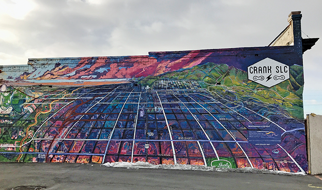
But the public maps that I enjoy most are the more informal ones painted by local artists. Chris Peterson is responsible for the most extensive public Salt Lake City map I've seen, which is located on the now-defunct Crank SLC bike shop on State Street between 700 South and 800 South (above photo). This vividly colored, curved perspective piece shows the majority of the city north of 900 South, stretching from the far west to the east bench.
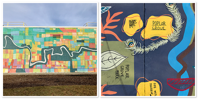
Peterson is also responsible for an incredible piece painted on the Sorenson Multi-Cultural Center at 900 West and California Avenue, which shows the topography of the Jordan River and what looks like neighboring housing tracts of adjacent west side communities (bottom left).
Another more playfully designed Jordan River map can be found on the ground at Poplar Grove Park at Emery Street and Indiana Avenue and is the creation of Miriam Gutierrez (bottom right). Public parks within the Glendale, Poplar Grove and Fairpark neighborhoods are highlighted in this piece and, although only relative locations are given, I have full confidence that even the most amateur of navigators will still be able to find them: that's the power of the grid!
More by Bryant Heath
-
A street by any other name would still lead to the Utah State Capitol
Small Lake City
- Mar 13, 2024
-
It may not seem like it, but most of Salt Lake City sits west of the freeway—waaaaay west.
Small Lake City
- Dec 6, 2023
-
Salt Lake's City and County building is a time capsule from the past with a view to the future
Small Lake City
- Nov 1, 2023
- More »
Latest in News
Readers also liked…
-
Raise a glass for E.L.T Harrison, architect of the Beerhive building on Main
Small Lake City
- Oct 11, 2023

