

Monumental Decision
Environmentalists and recreationists warn that unless Obama designates Greater Canyonlands National Monument, state control and its love of oil will destroy Southern Utah
By Eric W. Trenbeath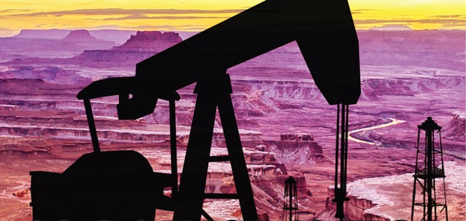
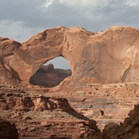
Fifty years ago, President Lyndon B. Johnson signed legislation to protect a remote corner of Southeastern Utah. The wild and strangely beautiful landscape—the standing remnants of the erosional forces of the Green and Colorado rivers—is cut apart by deep canyons; faulted and warped by buried salt domes; and covered with rock spires, towers, buttes and mesas.
The quest for the area to receive national park designation was fiercely contested by Utah politicians, many rural residents and those who represented mining, grazing and oil & gas interests. And when, on Sept. 12, 1964, it was all said and done and the area was officially designated as Canyonlands National Park, the final boundaries represented but a fraction of what the park's original visionary, Bates Wilson, had intended.
Seemingly arbitrary lines had been drawn without regard for the landscape and its features. Seen on a map, the boundaries appear as severe right angles, in complete contrast with the sinuous curves of the landscape, the rivers, and especially the distant cliffs that define the Canyonlands Basin.
Walt Dabney, superintendent of Canyonlands National Park from 1991 to 1999, says that the original proposal went from "rim to rim," which would have taken in the entire erosional basin from the Orange Cliffs on the west to their counterpart cliffs above Lockhart Basin to the east.
"There is an assumption by visitors who stand at Grand View Point that they are looking at Canyonlands National Park," Dabney says. "But what they are actually looking at is an illogical and political compromise that resulted in only a part of the basin being protected."
And today, with oil, gas and mineral development fast encroaching on the current boundaries, the land—63 percent of which is open to oil & gas development—is once again at the center of a political firestorm over how it should be managed, both for the sake of the land and its users, and for its highest economic benefit.
A movement to expand the park to its original vision and beyond is gaining momentum, as a coalition of local, regional and national environmental groups—including the Sierra Club, the National Resource Defense Council and the Southern Utah Wilderness Alliance—have banded together as the Greater Canyonlands Coalition to lobby President Obama to designate 1.8 million acres as Greater Canyonlands National Monument.
The coalition is joined by the Outdoor Industry Association and more than 100 outdoor businesses, signifying a new front in the fight to protect public lands—not only for their wilderness and scenic values, but also for their economic benefits.
Outdoor recreation is big business in Utah, bringing in $6 billion to the state annually. In Moab, "Utah's Adventure Capital," outdoor recreation contributes more than $250 million a year to the local economy, and accounts for more than 40 percent of the jobs.
In July, Headwaters Economics updated a study that found that national-monument designations were consistent with economic growth in adjacent communities, and that counties with more than 30 percent of their land base under federally protected status showed an increase in job rates at four times that of similar counties with no protected public lands.
But the opposition to a monument is no less intense than it was 50 years ago. Some fear a monument will result in a loss of potential jobs and mineral royalties. Others are opposed on philosophical grounds. To them, the idea that a president can, by executive order, declare almost 2 million acres of land a national monument is the ultimate overreach of a heavy-handed federal government.
San Juan County Commissioner Phil Lyman, made famous in May 2014 for his ATV protest ride in Recapture Canyon, says "the notion that the president would use his executive power" is an affront to all "freedom-loving people."
An executive order, Lyman says, "circumvents the process. It ignores Congress, but more relevant to a county commissioner is that it ignores the county. These types of decisions are best made by locals."
Lynn Jackson, county council chairman in neighboring Grand County— home to the town of Moab, Arches and Canyonlands National Park, and almost 1,700,000 acres of federally managed public lands—says it's possible to balance scenic and recreational values with resource extraction, and he is dead set against a monument.
Speaking on his own behalf, Jackson, a geologist and former Bureau of Land Management supervisor, says he takes "issue with the ability of a small group of environmental activists who try to convince a president to use the authority of the 1906 Antiquities Act to set aside millions of acres of land with the stroke of a pen."
But monument proponents maintain that public lands belong to all Americans—not just to those who live there, who may have a shortsighted vision for their management. Many believe that if state and local control prevailed, Utah's public lands would be sold off to the highest bidder regardless of their scenic, biological or recreational values.
Bill Hedden, executive director of the Grand Canyon Trust, says state and local governments are ill equipped to manage federal lands. "While local elected officials have a valid voice in their management, they have no business trying to override the interests of the American people."
Oil Land in the Sky
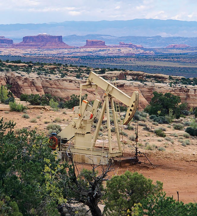
Canyonlands has roughly 450,000 annual visitors, and about 60 percent of them visit the Island in the Sky district. The "Island" is a high, peninsular mesa perched above and between the twisting canyons of the Green and Colorado rivers.
Visitors to the Island enter the park via Utah Scenic Byway 313, about nine miles north of Moab. The road heads west and immediately enters a canyon with low cliffs of rust-colored Wingate sandstone. Alcoves hollowed into the rock by wind and water contain evidence of early habitation by the Fremont and Desert Archaic people, and the walls are decorated with vivid rock art panels dating back 5,000 years or more.
As the road climbs up out of the canyon through a pair of hairpin switchbacks, the view opens up on a grand scale. In the foreground, immediately to the north, are the towering and monolithic buttes of Monitor and Merrimack. To the east, the strangely eroded forms of Arches National Park give way to the undulating curve of the Uncompahgre Plateau, stretching all the way to Colorado.
Slightly south, home to the Gemini Bridges jeep-and bike-trail complex, a plain dotted with pinyon pine and juniper faults upward to the Gold Bar Rim, beyond which the 13,000-feet-high peaks of the La Sal Mountains jut up from a jumbled maze of sandstone fins and incised canyons.
To the west, one can see the entire length of the San Rafael Swell, the Henry Mountains, Factory Butte and, on a clear day, all the way to Boulder Mountain near Capitol Reef National Park. In the foreground, the sinuous canyons of the Green River begin to emerge as they wind their way toward the confluence with the Colorado River, the centerpiece of Canyonlands National Park.
Until just a few years ago, the view was largely empty of manmade objects. Night skies were dark, and not a light could be seen in any direction, save the traffic on Interstate 70, 40 miles to the north.
Now, towering drill rigs, lit up like Christmas trees, dot the landscape. Natural-gas flares light up the night sky, and well pads fitted with storage tanks and nodding horse-head pump jacks are appearing within sight of the park boundary.
Mathew Gross, SUWA's campaign director for Greater Canyonlands, says this is just the first step toward transforming the Big Flat area into what local conservationists are now calling "Oil Land in the Sky."
"This area is being transformed far more quickly than people realize, or that the oil & gas cheerleaders want to admit," Gross says. "The future of Greater Canyonlands without monument protection can already be seen if you drive up Highway 313 to the entrance of Dead Horse Point and Island in the Sky."
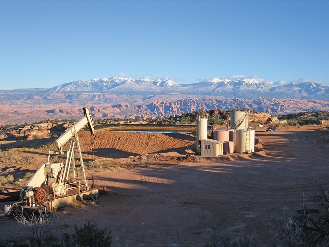
Fidelity Exploration & Production has plans to develop 61,000 acres of land on Big Flat immediately adjacent to the border of Canyonlands and Dead Horse Point State Park. The oil & gas company currently has 23 wells in operation, with plans for up to 50 more.
Fidelity spokesman Tim Rasmussen says the company uses the best management practices to limit impacts to the area's unique natural resources.
"Fidelity plans to develop a fairly large area of land with minimal disturbance by permitting a very small number of discretely placed well pads," Rasmussen says. This equates to a disturbance footprint of approximately 0.4 percent, or 250 acres, of the entire developed area.
Critics say that in spite of those numbers, the area will be transformed into an industrial zone, with a network of roads, drill pads and an above-ground pipeline. And Fidelity is just one company. When the BLM completes its Master Leasing Plan later this year, and more parcels come up for lease, there could be as many as 200 wells in the area.
"People don't come from all over the world to see oil wells in the canyon country," says Moab resident Bill Love, who has been monitoring the development and raised numerous concerns about safety standards on a natural gas pipeline that is currently under construction.
"The industrialization of the Big Flats area can be a significant loss to the tourist industry in Grand County over the life of the field," he says. "Each year, the tourist industry provides hundreds of millions of dollars of income to the economy of Grand County, while oil & gas development will only provide 2 to 5 million annually."
In 2012, the Outdoor Industry Association sent a letter to Obama urging him to protect Greater Canyonlands on the grounds that "The future of our outdoor recreation economy depends on protecting iconic landscapes such as Greater Canyonlands. And monument proclamation is an important and effective way to provide the protection that is needed."
The letter also says, "Greater Canyonlands is endangered. Federal land-use plans inappropriately open scenic and undeveloped land to drilling and mining and fail to address exploding off-road vehicle use that is damaging riparian areas, cultural sites, soils and solitude."
Jackson says he respects those who believe the area is being turned into an industrial zone, but he doesn't share that opinion. He is taking the long view, he says, and doesn't believe oil & gas development will affect tourism.
"These wells and this field will be developed and reclaimed over a few decades and the lands will remain," he says. "My goal is to continue to find ways to accommodate all uses in the area."
He says the field will provide significant revenue to the county, and that it is a relatively small development that will have minimal impact on the landscape.
"Big fields in other parts of the country often have between 500 to 5,000 wells," Jackson said. "So on a relative scale, this field, at full development, is several orders of magnitude smaller."
It is estimated that Big Flat oil field will produce about 30 million barrels of oil over the next 30 years. Proponents say it will also bring higher paying jobs to the area, but Love says that oil companies bring in their own crews, and that the overall amount of oil produced will be insignificant on a national scale.
According to statistics from the U.S. Energy Information Administration, the United States consumed 18.8 million barrels a day in 2013—in other words, 30 million barrels of oil are just a drop in the bucket.
First Steps
Big Flat isn't the only area within the monument proposal that is slated for oil, gas and mineral development: 210,000 acres within the proposal are already leased, and up to another 1 million could be available pending the finalization of the MLP. All told, 63 percent of the lands within the proposed monument area are open to potential development.
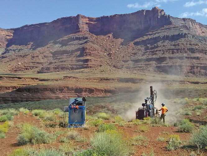
In September, Fidelity began 3-D geophysical seismic work on Hatch Point, about 15 miles south of Moab. The area being surveyed is approximately 50 square miles, and is contained entirely within the Canyon Rims Recreation Area. Three scenic viewpoints, as well as Hatch Point Campground and the Trough Springs trailhead, lie within the project area.
Seismic work is performed by laying out a grid pattern of "source lines" across the landscape. A shock wave is created at various source points along those lines, either with a buried explosive device or with vibroseis trucks, sometimes called thumper trucks.
Thumper trucks drive cross-country, over vegetation and natural features, and thump the ground at source points with a large, hydraulic weight. The shock wave reflects off of geophysical structures underground, and is picked up by a device called a geophone. The resultant data is used to map the underlying structure to help geologists determine where oil can be found.
"It's disingenuous to say these lands enjoy any current protection when a thumper truck is coming right by your campsite in a designated recreation area," Gross says. "It just goes to show how the current management regime is failing, and why these are the places that need protection as a Greater Canyonlands National Monument."
About 4,000 acres of the project area spill over the rim into Lockhart Basin, the first modern incursion into the greater Canyonlands Basin. Source points in Lockhart are being placed with portable drills that are dropped in by helicopter. Though Rasmussen states emphatically that Fidelity has no plans to develop Lockhart, many fear that this is the first step toward industrialization "below the rim."
The Proposal
The concept of protecting a large chuck of southeastern Utah goes back as far as 1936 when Harold Ickes, secretary of the interior under President Franklin Roosevelt, proposed the 4.6 million acre Escalante National Monument.
The proposal encompassed lands surrounding the Colorado River and its tributary canyons along most of its course through Utah. It would have included most of what is currently proposed for Greater Canyonlands, the Colorado River country around Glen Canyon (now inundated by Lake Powell), Capitol Reef National Park, and what is now the Grand Staircase-Escalante National Monument, which was designated by President Clinton in 1996.
Opposition from the Utah congressional delegation, as well as the diversion of national attention to World War II, derailed the proposal, but in the 1950s, Bates Wilson, a young superintendent of Arches and Natural Bridges national monuments, began a quest to protect the area that would eventually become Canyonlands National Park.
Wilson found allies in then Secretary of the Interior Stewart Udall, and Utah Sen. Frank Moss. The three worked tirelessly on the political front, as well as on the ground, taking politicians on jeep and river tours into the remote and rugged canyonlands backcountry.
They succeeded in bringing the proposal before Congress, but the final designation of the park included only 277,000 acres, a fraction of the 990,000 acres proposed. An additional 60,000 acres was added in 1972 with the inclusion of the remote Maze District in the southwest portion of the park.
Dabney is advocating enlarging the park to its original "rim to rim" proposed boundaries and slightly beyond to include Beef Basin, upper Salt Creek, and Fable Valley, known for their shared archaeological heritage with the Canyonlands Basin.
Gross says that the rim-to-rim proposal doesn't go far enough—there are many more lands surrounding the Canyonlands Basin that are worthy of protection, he says.
"You can't just go rim to rim and protect the watershed," he says. "You need to protect the view shed. Otherwise you'll be standing at the Needles Visitors Center and be looking up at oil & gas wells. The sunset at Grand View Point will be echoed by flaring gas wells on Hatch Point."
The Greater Canyonlands Coalition is proposing the preservation of 1.8 million acres of public land surrounding Canyonlands National Park. Protection would be provided for outstanding scenic areas such as Labyrinth Canyon on the Green River; Lockhart Basin and Indian Creek within the Canyonlands Basin; the canyons of the Dirty Devil River and Robbers Roost country; as well as the archaeologically and culturally rich areas of upper Salt Creek, Beef Basin and the tributaries of White Canyon.
"The boundary was drawn with the manageability of the lands in mind," Hedden says. "We are trying to protect the world-famous wildness, silence, unspoiled vistas, dark night skies, critical watersheds, wildlife habitats, cultural resources and recreational opportunities."
Politics ... As Usual
In August, 14 senators, led by Dick Durbin of Illinois, sent a letter to President Obama urging him to designate a Greater Canyonlands National Monument.
"Greater Canyonlands is one of our nation's most stunning, wild, and scenic landscapes," the letter said. "It should be protected permanently for the benefit and education of future generations."
Commissioner Lyman says Durbin and the others "may be well-intended, but ... they are misinformed," and that Utah does not need another layer of federal intervention.
"Utah is beautiful not because of regulation, but because God made it that way," he says.
In response to the threat of a national monument, Utah Rep. Rob Bishop has been championing his "Grand Bargain," or "Utah Public Lands Initiative." He describes the process as "bottom up," whereby interested stakeholders and local communities work with their county representatives to draft a vision for federal land use within their jurisdictions. Bishop plans to package the local recommendations into a bill that he can present to Congress sometime next year.
At a Grand County Council meeting in July, Kathleen Clarke, director of the Utah Public Lands Policy Coordination Office, spoke of the "looming danger" of a national monument and urged council members to work with interested stakeholders, adding that, "We absolutely need the support of the environmental community."
The council had previously drafted three alternative land-use maps for the management of federal public lands within Grand County. Alternative 1 provided the least amount of protection for public lands, while Alternative 3 represented the council's version of a plan that would offer the most protection through wilderness designation.
The alternatives were widely seen by the recreation and environmental community as being almost entirely pro-development, offering very little as a range of possibilities for protective designations.
"Grand County's best alternative protects just over 50 percent of the proposed wilderness in Grand County, and leaves open to oil & gas drilling the entire view shed east of Arches National Park," Gross says. "At best, we could call Alternative 3 a starting point for discussion, but it's not much more than that."
The council has continued to revise its proposal by expanding wilderness designation and by forming a subcommittee to work on the designation of national recreation areas, but has yet to vote on a proposal and send it to Bishop.
In neighboring San Juan County, a group of stakeholders—ranchers; oil, gas & mining proponents; ATV enthusiasts; and one conservationist—has been meeting every two weeks for the past six months to draft a proposal for the county commission.
Their alternatives were released in October, and include a wide range of possibilities. Alternative 1, or the "unanimous alternative," designates as wilderness all of the 500,000 plus acres in San Juan County that is currently being managed by the BLM as Wilderness Study Areas. It also sets aside large tracts of land in Indian Creek, valued for its scenic and recreational values as a National Conservation Area.
Josh Ewing, executive director of the Friends of Cedar Mesa, says, "The respectful, collaborative and open-minded spirit of these discussions are a credit to what our community can accomplish if we work together and find common ground."
In August, Utah Republican Rep. Jason Chaffetz brought Democratic Rep. Elijah Cummings from Baltimore, Md., to Southern Utah to show him how people out here "really feel" about a monument and about federal control over public lands in general.
They attended a round-table discussion with rural county commissioners, many in boots and cowboy hats, with each speaker repeating how much they resented the intrusion of the federal government and how opposed they were to the creation of a national monument. No members of the public were present, nor any members of the environmental or recreation community.
After the meeting, they went to see Arches National Park. On the ride up, Chaffetz berated the Park Service, in the presence of park superintendent Kate Cannon, for its inability to manage the lands with which it's entrusted, and said it has no business taking on more. He cited the October 2013 government shutdown—which he'd supported—as the perfect example.
Chaffetz told Cummings that states were much better equipped to manage the public lands within their borders. The two then stopped for a photo-op at the Windows Section of the park. With the morning sun still rising, they couldn't pose with North Window Arch behind them, so they turned and faced east. In the distance, the developing Big Flat oil field could be seen over their shoulders.
For Antiquity
The Antiquities Act, which gives the president the power to designate a Greater Canyonlands National Monument, was passed by Congress, and signed into law by President Theodore Roosevelt on June 8, 1906. The act authorizes the president "in his discretion, to declare by public proclamation historic landmarks, historic and prehistoric structures, and other objects of historic or scientific interest ... to be national monuments."
The act has been used more than 100 times by presidents from both sides of the political aisle, including George W. Bush, Jimmy Carter and Dwight Eisenhower, and has established some of the nation's most beloved and visited national monuments, many of which eventually became parks, including Grand Canyon, Grand Teton and Arches.
Jackson says that while the Antiquities Act has indeed been used to protect revered national parks, "we need to rethink the Antiquities Act and bring it back in line with its original intent, protecting high-value areas of antiquities."
In their letter to Obama, the national senators made the case that Greater Canyonlands, as the ancestral home to several tribes of Native Americans, is the perfect candidate for protection under the Antiquities Act.
"It includes thousands of cultural and archaeological sites, a hunting site that dates back 12,000 years, and more recently built granaries nestled into the canyon walls," the letter said.
Will President Obama designate a Greater Canyonlands National Monument? At a Sept. 17 news conference, Utah Gov. Gary Herbert said that Secretary of the Interior Sally Jewell assured him that "a monument wasn't imminent," and that she would tell him if it were.
But Hedden says that protection of Greater Canyonlands by executive order is necessary now because of unprecedented threats to the region from new drilling technologies and modern off-road vehicles.
"It is time to finally redraw the boundary the way it should have been from the start," Hedden says, "so that this remarkable place can be managed for its highest uses as a repository of our cultural history, haven of biodiversity, and a refuge and inspiration for people from all over the world."
Related Stories
-
Monumental Pushback
Mar 1, 2017
Latest in Cover Story
Readers also liked…
-
Forget the family pedigree—Robert F. Kennedy Jr should not be the next president of the United States
Trojan Horse
- Jun 21, 2023
-
Women decry harassment and toxic culture at St. George auto dealership
Men at Work
- Oct 11, 2023

